Auchencorth River Cliff
Local Geodiversity site | Midlothian
Local Geodiversity site | Midlothian
Scotland's geosites are chosen because of their local, national or international importance. Take only photos, leave only footprints: avoid causing any damage to this site. You can walk almost anywhere in Scotland without the need to ask permission or keep to paths, but you have a responsibility to care for your own safety, to respect people's privacy and peace of mind and to cause no damage.
The right of access does not extend to quarries, building sites or any land where public access is prohibited, or to the collection of geological samples.
A river cliff about 10 m high, just above the channel of the River North Esk, which exposes several metres of sandstones overlying two coal seams, which are interbedded with black siltstones and underlain by a thin, pale grey clay. Other rocks in the sequence at the base of the exposure are obscured by siltstone scree and sandstone boulders.
A steep rock face which exposes sandstones, siltstones and coal seams of the Lower Carboniferous Limestone Coal Formation, Clackmannan Group (Namurian) can be found close to the River North Esk in the gorge downstream from the settlement of Marfield. The exposure is about 10 m high in total with yellow and white sandstones forming the upper half of the cliff. Below the sandstones is a sequence of siltstones with two coal seams, both less than 30 cm thick. Between and beneath the two coal seams are laminated black siltstones, probably rich in organic material as they include shiny carbon films on some surfaces. About 20 cm below the lower coal seam is a bed of pale grey clay which may represent a seat earth, a deposit often associated with coal seams. All these rocks are heavily impregnated with iron which gives them an orange-brown colour and the lower coal seam also has yellow colouration resulting from a high sulphur content. Iron nodules were seen on the scree slopes and have probably fallen from the siltstones above.
Park at NT 1966 5724, avoiding blocking access to gates. Follow the track west along a field wall to reach the valley of the River North Esk, where there is a track sloping north-west downhill across rough grassland. The exposure is not visible from above, as it is a vertical cliff opposite the ruined building on the west side of the river. It is necessary to scramble down a very steep heather-covered slope taking great care, then working upstream along the bank above the river until the exposure becomes visible.
There is a ruined building on the river flood plain opposite this exposure, which, judging from its size, was probably a mill.
The steep gorge of the River North Esk is picturesque, with trees and pastures along the flood plain and occasional rock exposures.
Mitchell, G.H. & Mykura, W. 1962 The Geology of the Neighbourhood of Edinburgh. Memoir of the Geological Survey, Scotland pp.91&127
Tulloch, W. & Walton, H.S. 1958 The Geology of the Midlothian Coalfield. Memoirs of the Geological Survey of Scotland pp.55-56
http://scans.bgs.ac.uk/sobi_scans/boreholes/650555/images/1…
To study the scan of the 1952 Hare Moss No. 241 borehole (reference number NT15NE62) see the BGS website.
OS 1:50,000 Map 66 Edinburgh
OS 1:25,000 Explorer 344 Pentland Hills
https://largeimages.bgs.ac.uk/iip/mapsportal.html?id=1002357
BGS 1:50,000 Scotland Sheet 32E Edinburgh
The river cliff is a rare exposure of coal seams in the Midlothian Coalfield and is associated with channel sandstones and siltstones which give an environmental context.
There are no safety notes yet.
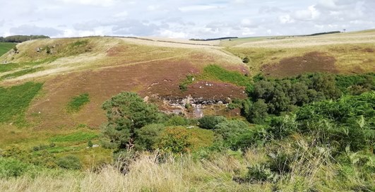
View of the river cliff exposure from Marfield at NT 18970 56914 looking north-east over Auchencorth Moss. The exposures on the left, on the edge of the plateau, are part of the Upper Limestone Formation, while, in the distance, Auchencorth Moss is underlain by the sandstones of the Passage Formation. The river cliff shown on the steep side of the valley just above the trees and lying below the Upper Limestone Formation, is therefore part of the Limestone Coal Formation.
Alison Tymon
Sept. 9, 2022
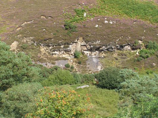
A closer view of the Limestone Coal Formation rocks from the opposite side of the valley at Marfield shows cross-bedded massive sandstones, lying above a grey-coloured scree of siltstones.
Alison Tymon
Sept. 9, 2022
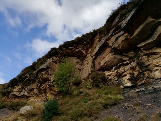
This view looks upwards at the north-west end of the exposure where 7/8 m of medium to coarse-grained sandstones can be seen, mostly in massive beds up to 1.5 m thick. In the lower 2 m, the beds are trough and cross-bedded, with 50 cm sets of medium-grained, iron-stained sandstone containing carbon streaks. Branch fossils were seen in the higher sandstone beds. Below the slight recess, under the overhanging massive sandstones, can be seen grey siltstone beds.
Alison Tymon
Sept. 9, 2022
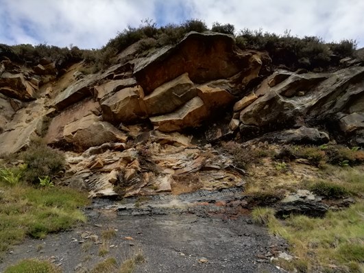
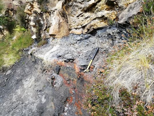
The sequence from the massive sandstones to the coal seams and black siltstones below is visible in this view. Because the lower sandstones are more closely bedded, they are more vulnerable to weathering and therefore form a recess under overhanging massive sandstones. There are two coal seams which show up as darker beds with fine sub-vertical joints, separated by a thin bed of reddened siltstone which is also found below the lower coal seam.
Alison Tymon
Sept. 9, 2022
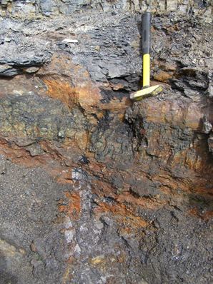
The contact between the sandstone and the upper coal seam, which ranges in thickness from 25-30 cm, is irregular, showing some 3-4 cm of scouring. Below the upper coal seam is 36 cm of black siltstone with carbon films and mica flakes. Below the hammer head is the lower coal seam which is 17 cm thick and is stained yellow from sulphur and reddened with iron. Hammer is 33 cm long.
Alison Tymon
Sept. 9, 2022
Orange and black-stained hardened siltstone beds 17 cm in thickness, below the lower coal, overlie 16 cm of pale grey clay from which fallen scree has been removed with the hammer. This bed may be a seatearth, although it does not lie directly below either of the coal seams. Below this exposure, the beds are covered with considerable thicknesses of siltstone scree and large boulders of sandstone.
Alison Tymon
Sept. 9, 2022