Black Burn, Halls Bridge
Local Geodiversity site | Midlothian
Local Geodiversity site | Midlothian
Scotland's geosites are chosen because of their local, national or international importance. Take only photos, leave only footprints: avoid causing any damage to this site. You can walk almost anywhere in Scotland without the need to ask permission or keep to paths, but you have a responsibility to care for your own safety, to respect people's privacy and peace of mind and to cause no damage.
The right of access does not extend to quarries, building sites or any land where public access is prohibited, or to the collection of geological samples.
An exposure of three glacial tills with different physical characteristics and compositions on the valley side next to Black Burn on Auchencorth Moss. The lower slopes are obscured by clay and stones but it is possible to see several metres of each till at the top of the exposure.
The exposure of glacial tills can be found close to Halls Bridge on the A701 in the valley of Black Burn, a tributary which joins the River North Esk near Penicuik, having drained the south side of Auchencorth Moss. This site is easily accessible from the A701 but there are other exposures of glacial till along Black Burn, including one on the south side of the valley opposite the exposure illustrated below.
At the top of the eroded slope several different tills, of slightly different colours and different clast compositions are visible. The contact between each till is not clear, as the lower part of the exposure is covered by material washed downslope and the upper section is vegetated in part.
There is parking for several vehicles on the south side of Halls Bridge and access to the river banks is through a gate on the north side of the bridge.
Auchencorth Moss is an extensive peat-covered plateau, dissected by small streams and drainage channels. Views from the Moss towards the Moorfoot and Pentland Hills are attractive.
https://www.lyellcollection.org/doi/abs/10.1144/sjg04030209
Kirby, R.P. 1968 The ground moraines of Midlothian and East Lothian. Scottish Journal of Geology, Vol. 4, pp.213-215.
https://webapps.bgs.ac.uk/memoirs/docs/B01944.html
Mitchell, G.H. & Mykura, W. 1962 The Geology of the Neighbourhood of Edinburgh. Memoir of the Geological Survey, Scotland pp.111-114.
While there is a considerable cover of glacial till in Midlothian, it is not easy to find good exposures which have not been overgrown. This glacial till site is easily accessible and is likely to remain visible for study.
There are no safety notes yet.

Photo 1 The view of the whole site from close to Black Burn at NT 23167 57643, bearing 280°.
Alison Tymon
Sept. 9, 2022
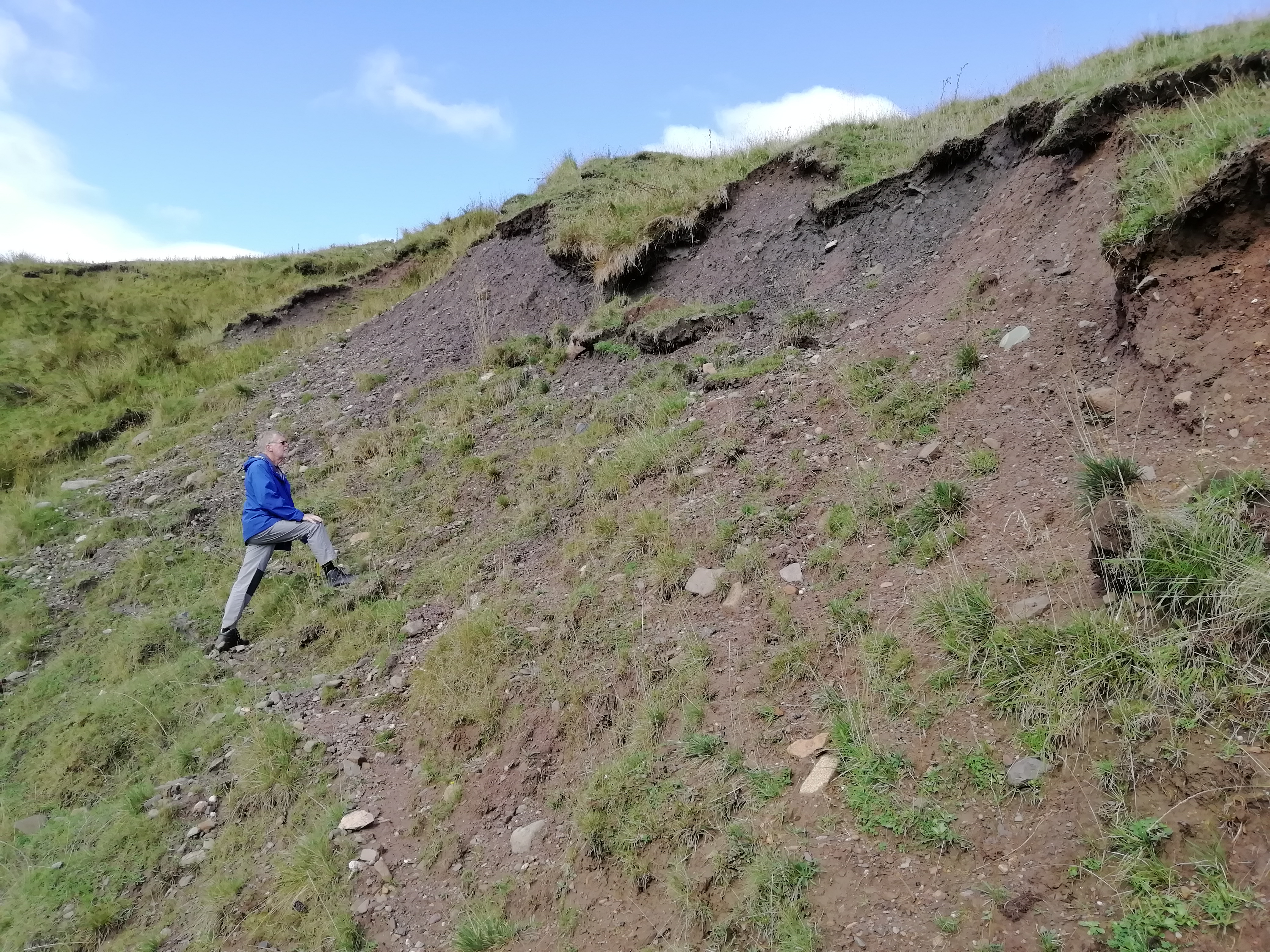
Photo 2 shows a closer view of the exposure. The till at the top of the exposure in the far distance is brown in colour, with dark grey till in the middle of the photo. To the right in the foreground is a brighter red-brown till. The total thickness of each till could not be measured because of the amount of soil wash covering the exposure. NT 23150 57647, bearing 280°.
Alison Tymon
Sept. 9, 2022
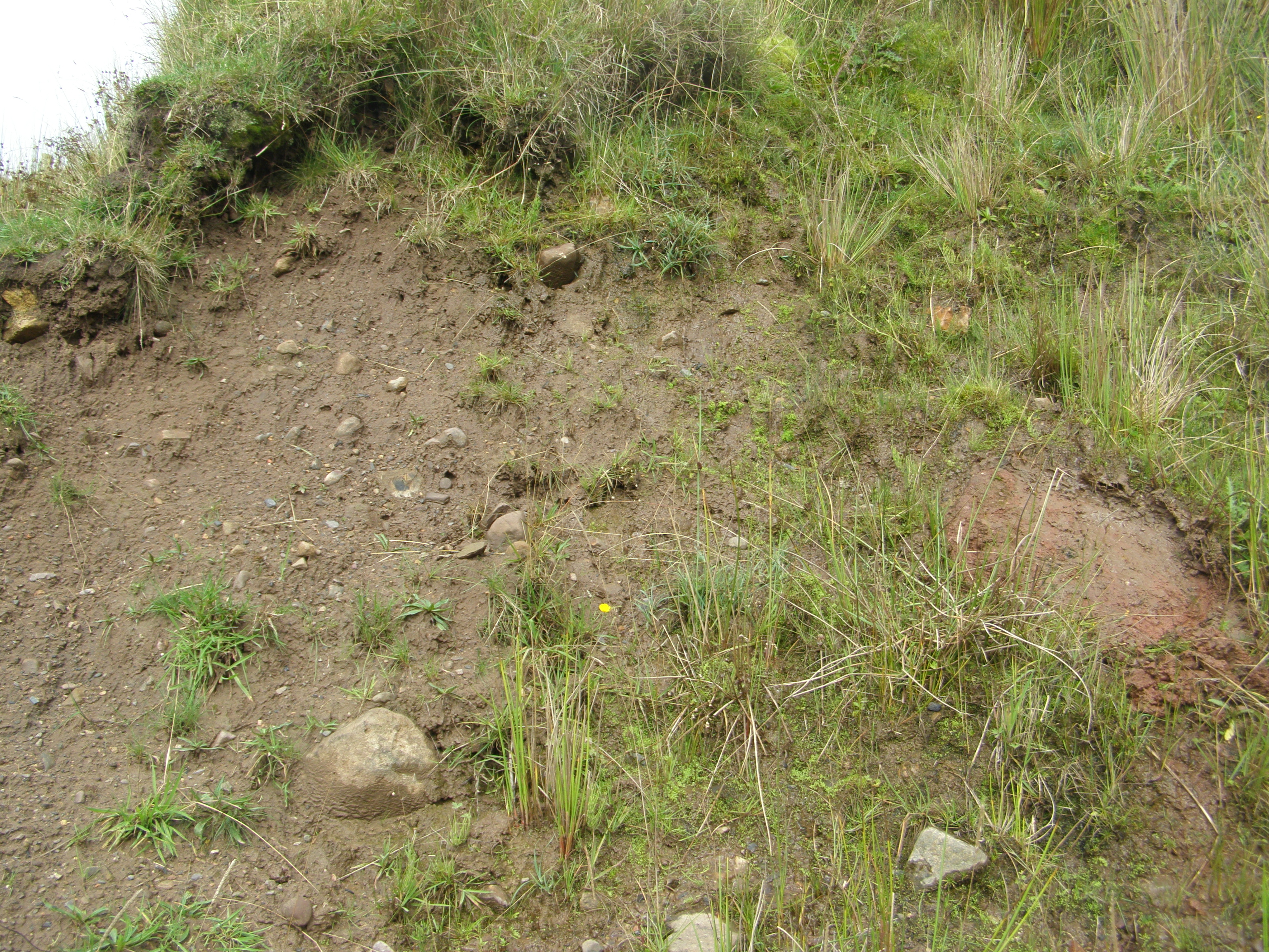
Photo 3 The upper exposure at the west end of the site is a brown matrix-supported till containing stones with a variety of sizes and compositions. There is an in situ red sandstone block on the right of this picture, which was exposed by scraping away the overlying till. The larger stones are sub-rounded, while the smaller stones have a tendency to sub-angularity. NT 23126 57657
Alison Tymon
Sept. 9, 2022
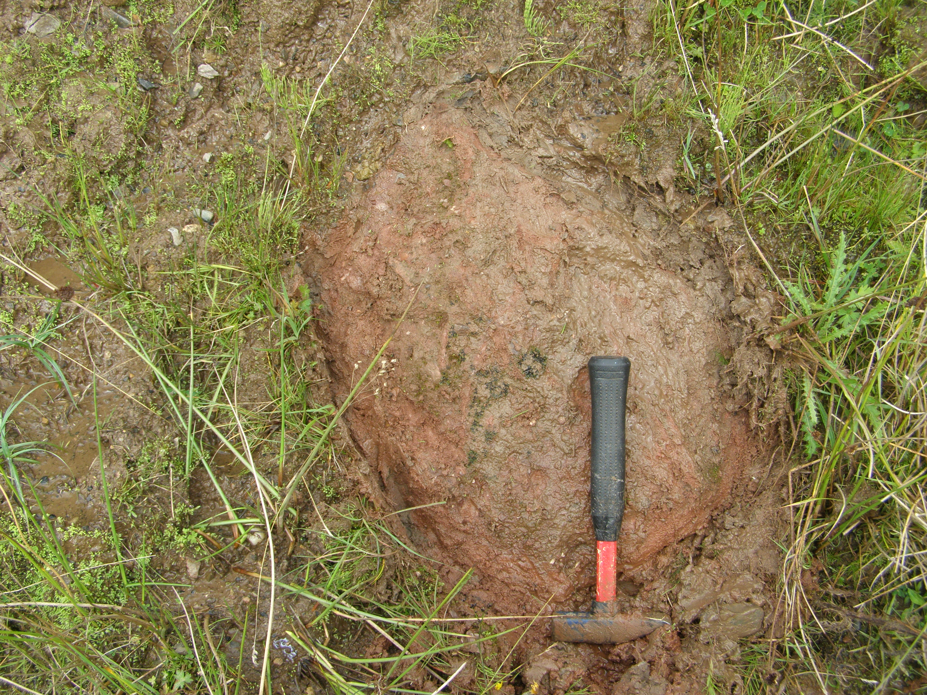
Photo 4 shows the in situ red sandstone block which is embedded in brown clay, as seen in Photo 3, and has dimensions of at least 52 x 38 cm. The hammer is 28 cm long.
Alison Tymon
Sept. 9, 2022
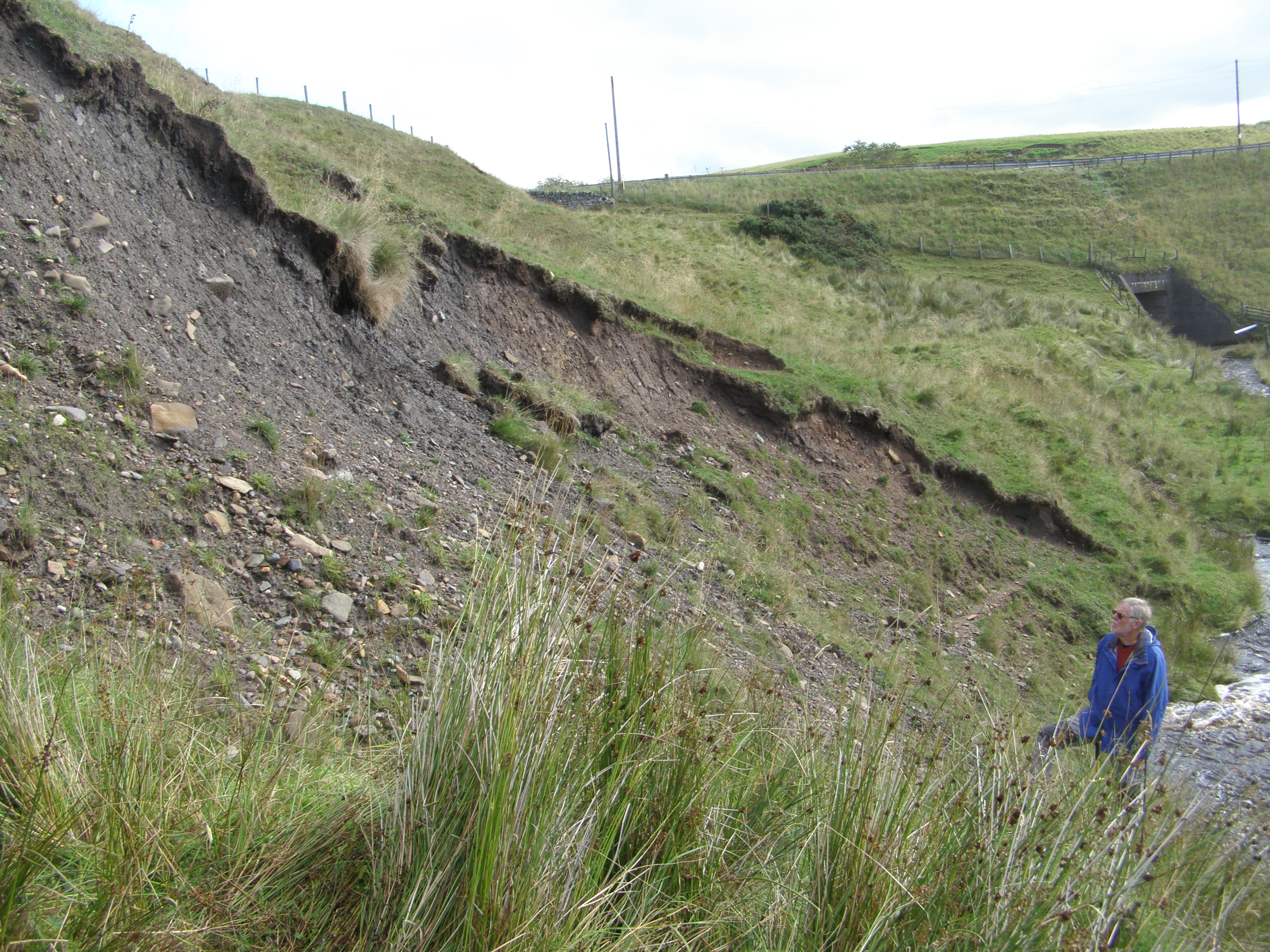
Photo 5 This is the view looking across the till exposure towards the A701 as it crosses Halls Bridge. The exposure shows the dark grey till on the left with many loose stones at the foot of the scree slope, amongst which are red and yellow fine-grained igneous rocks. At least one large boulder showed striations. Beyond and at a lower level, is the red-brown till seen in Photo 7. NT 23141 57657, bearing 281°.
Alison Tymon
Sept. 9, 2022

Photo 6 The fresh dark grey colour of this till, found at the highest point in Photo 5, is seen in the area below the hammer, although the weathering colour of the till is dark brown. Several large rounded boulders can be seen embedded in the till and pale igneous rocks of various colours can be identified. Many of the smaller clasts are angular in shape. Hammer is 28 cm long.
Alison Tymon
Sept. 9, 2022
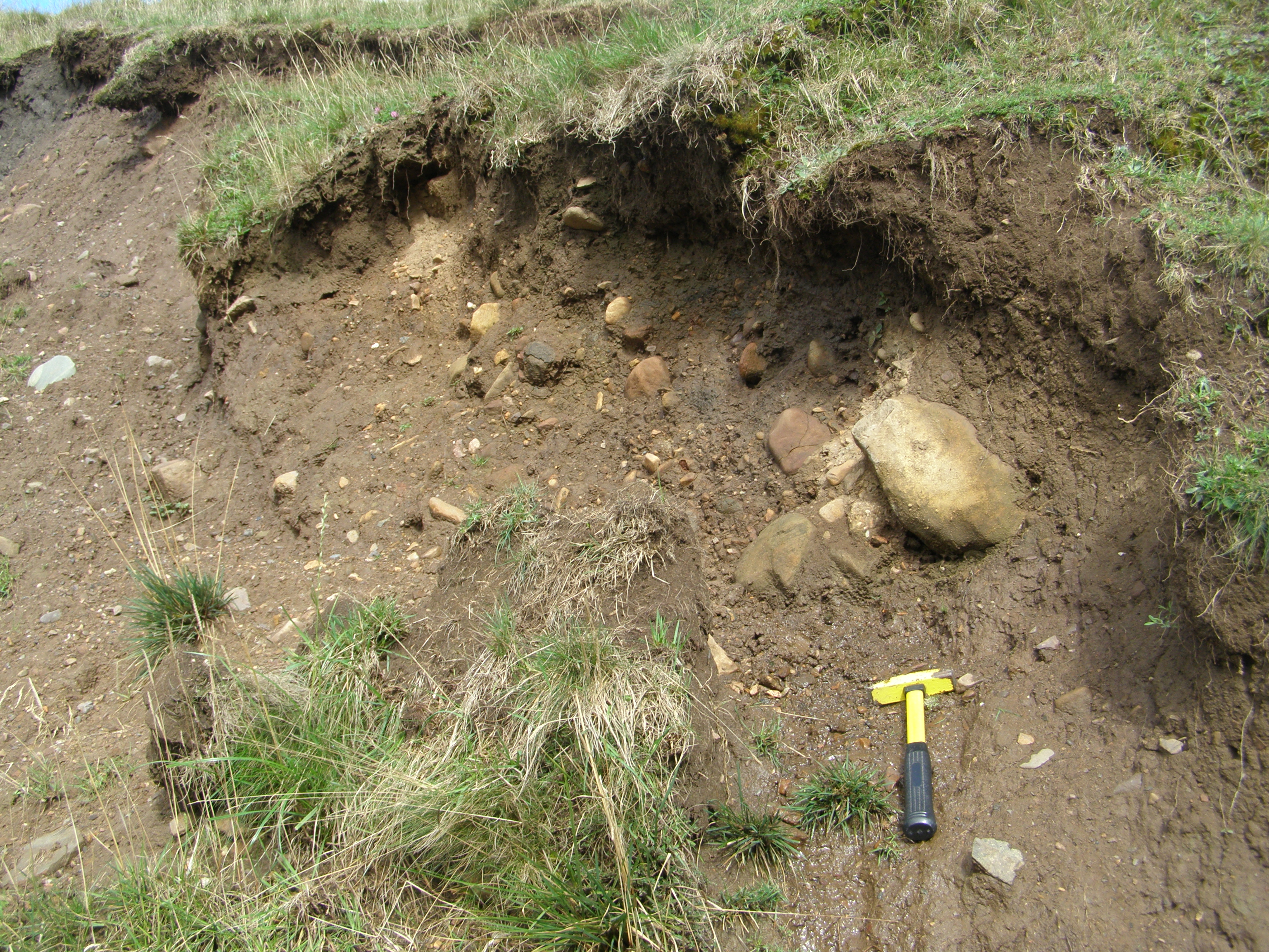
Photo 7 This exposure of brown till is found at the east end of the site at NT 23150 57647. Here the till has a higher proportion of large stones, compared with the other tills. Just above the hammer the till is clast-supported, as several large stones are in contact with each other. The stones have a variety of compositions and include a rounded black block, which appears to be exfoliating basalt or dolerite. The hammer is 33 cm long.
Alison Tymon
Sept. 9, 2022

Photo 8 View from the A701 as it crosses Halls Bridge looking south-west, showing the opposite side of the Black Burn valley. A second exposure of superficial material can be seen on the south side of the burn and its material is presumably similar to the glacial tills on the north side. However, access was difficult because of the fence, as seen in the photo.
Alison Tymon
Sept. 9, 2022