Balnakeil
Geological Conservation Review site | GCR #3259 | Geomorphology | Coastal Geomorphology of Scotland
Geological Conservation Review site | GCR #3259 | Geomorphology | Coastal Geomorphology of Scotland
Scotland's geosites are chosen because of their local, national or international importance. Take only photos, leave only footprints: avoid causing any damage to this site. You can walk almost anywhere in Scotland without the need to ask permission or keep to paths, but you have a responsibility to care for your own safety, to respect people's privacy and peace of mind and to cause no damage.
This site is a Site of Special Scientific Interest (SSSI). It is an offence to intentionally or recklessly damage the protected natural features of a SSSI, and this includes unauthorised sample collection.
The right of access does not extend to quarries, building sites or any land where public access is prohibited, or to the collection of geological samples.
The sand dunes at Balnakeil are some of the most active in Scotland and display the interaction between the erosion and deposition of sand. Waves undercut and erode the front of the dune whilst strong winds drive the eroded dune sand inland and uphill.
The peninsula of An Fharaid encloses Balnakeil Bay and lies at the entrance to the Kyle of Durness. It contains a spectacular array of beach and dune landforms, ranging from undercut dune faces to large and active dune blowthroughs. Large blowthrough corridors and mobile sand waves carry windblown sand across An Fharaid peninsula, from the beaches on the west coast to a prominent cliff on the east of the site. Coastal grassland has stabilized much of the blown sand deposits on the higher slopes in the north and east of the peninsula. These contrast with the lower altitude, highly active dunes and blowthrough corridors. The dunes at Balnakeil are some of the most active in Scotland. All stages in the development of sand dunes can be seen at the site, from mobile dunes on the foreshore to fixed dunes with marram, and climbing dunes and dune grassland further inland.
(From NatureScot SSSI citation)
Parking at the road end in Balnakeil by the old kirkyard (NC39156865). A vehicle track runs N along the back of the beach, and there are footpaths through the dunes.
https://www.geograph.org.uk/photo/3990308
The section of road most affected by sand transport.
https://www.geograph.org.uk/photo/5768442
A dune slack and a slightly eroded dune.
https://www.geograph.org.uk/photo/5103430
One of the blowthroughs.
https://www.geograph.org.uk/photo/4009395
The dune toe in the southern section.
There are no safety notes yet.
There are no site highlights yet.
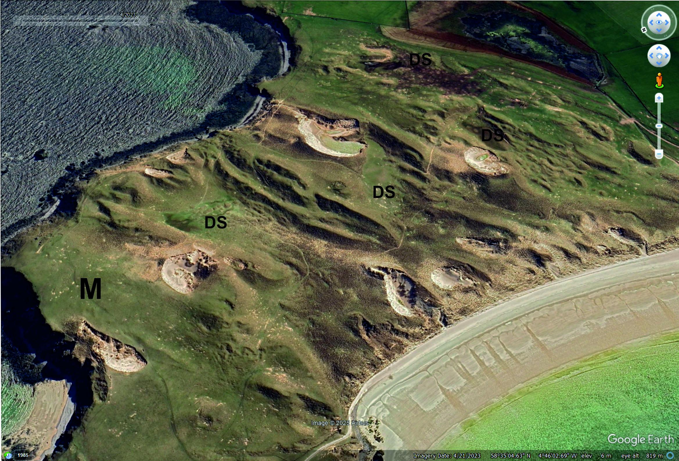
Oblique satellite image, close up of the dunes in the southern part of the site. M = machair, DS = dune slacks. Image © 2025 Google Earth.
Carol Pudsey
April 20, 2023
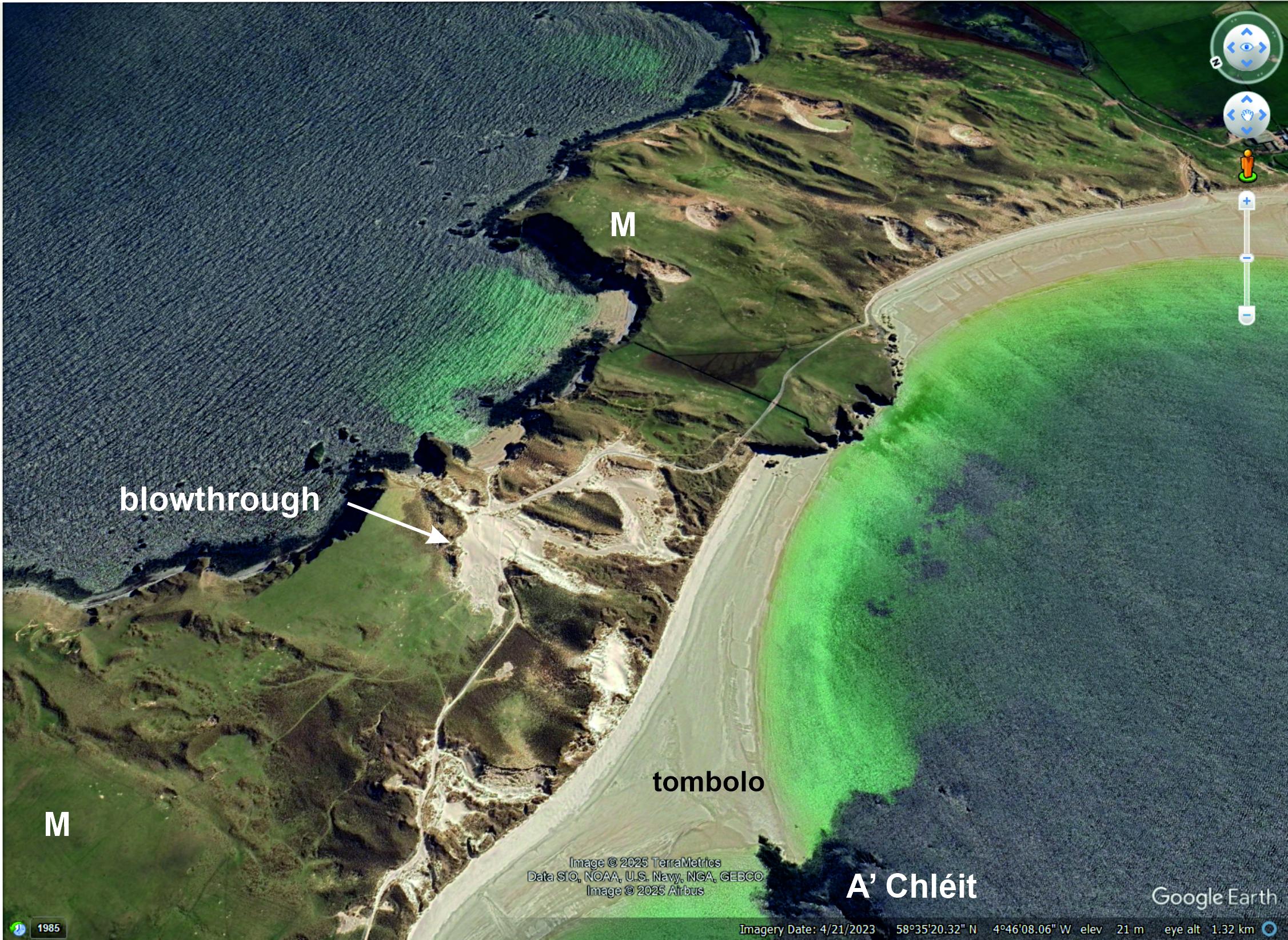
Oblique satellite image looking SE across An Fharaid, Balnakeil Bay on the right. Prevailing wind and sand transport direction right to left. M = machair. Image © 2025 Google Earth.
Carol Pudsey
April 20, 2023